
AscendXYZ featured on Innovation News Network
Recently AscendXYZ has been featured on Innovation News Network and will also appear in the eighth edition of its quarterly publication.
AscendXYZ is disrupting the bird strike prevention market with the world’s first airline-centric solution – Ascend Avian Radar Network (AARN).
Ascend provides a series of solutions all aimed at the reduction of bird strikes in aviation. Over the last five years, these solutions have been implemented in Aalborg Airport with amazing results – after implementing the avian radar, the number of strikes in 2018 dropped by 75%. The next step is to make the radar-measured bird risk forecasts available to airlines and pilots. This works like a weather forecast and enables pilots to mitigate the risk when the probability of a strike is high.
The nature of the aviation industry makes it uniquely vulnerable to a multitude of elements, ranging from airports operating their runways at 99% capacity to collisions between birds and aircraft. Bird strikes are an increasing problem for the aviation safety. US Federal Aviation Authority (FAA) reported a 38% growth in bird strikes from 2009 to 2015 and has noted that bird strike incidents have shown an alarming trend of significant growth.
One of the problematic aspects in minimising bird strike risk in aviation is the fact that responsibility and cost distribution is quite complicated; active mitigation is in the hands of airports, while major costs are incurred by airlines without having the possibility to mitigate the risk more proactively. Bird strikes are an industry problem; thus, seeking noticeable results should be tackled by all parties. Therefore, after a close collaboration with the industry, AscendXYZ introduced a new approach and suitable solutions both for airports and airlines.
Read the full article here.

The AARN project has received funding from the European Union’s Horizon 2020 research and innovation programme under grant agreement No 880308.

AscendXYZ has won a Horizon2020 grant for further development of a revolutionary solution
There is something exciting that AscendXYZ has been keeping under the radar (pun intended) for quite some time. AscendXYZ has recently been awarded a €1.2 million European Union’s grant under the 2020 research and innovation programme.
Horizon 2020 is the biggest European Union Research and Innovation programme ever with almost €80 billions of funding available over 7 years (2014 to 2020) in addition to the private investments this funding instrument attracts. The programme aims to support a successful rollout of highly innovative breakthrough ideas and solutions, support discoveries and aid world-firsts from prototype or lab phase to the market. Horizon 2020 is the financial instrument implementing the Innovation Union, a Europe 2020 flagship initiative aimed at securing Europe's global competitiveness. The goal is to ensure thatEurope produces world-class innovation and helps to fight barriers delivering that innovation to the market.
Horizon 2020 SME Instrument is looking for innovation that targets new markets, is aiming to bring novel approaches, offer ground-breaking solutions, and have exceptionally high potential. We are proud to have our idea recognised as high-potential disruptive innovation, that together with the help of funding, will be matured and brought to global market. AscendXYZ is grateful and proud to be chosen among top 5% of applicants from all over Europe and is strongly motivated to successfully bring the matured solution to the aviation industry.
Since this Horizon2020 grant is soft funding (meaning no strings attached besides doing our best to successfully implement the project), receiving this grant gives us certain freedom to bring a very specific solution to life that solves important challenges for the aviation safety while keeping the focus on development and successful commercialisation.
But what is it that AscendXYZ is presenting to the aviation world that got the attention and backing of the EU? Well, without further ado we present you the Ascend Avian Radar Network or AARN. A solution that does not exist in the market but has been something that our customers have been looking for. We wish to accelerate the delivery of a long-sought solution. We are disrupting bird strike prevention with the world’s first airline-centric solution. AARN connects multiple Ascend (and 3rd parties’) radars in multiple airports to deliver airlines and their pilots real-time bird activity data, forecasts, and warnings of high-risk periods in all airports that airline chooses to include in its subscription. The AARN is unique, since it offers airlines access to the real-time and historical radar data and predictions. It means that the AARN enables airlines to take a proactive approach in order to minimise the risk of a bird strike by mitigating it from an operational and planning perspectives. We think that the goal of the AARN is clear -improve airline profitability while increasing flight safety.
With the EU grant we are able to speed up the process of the AARN maturation and invest significant time and resources into making a unique solution available to the airlines. You can see airline avian radar solution in action in Aalborg airport here. The overall long-term goal of AARN is to, of course, decrease the risk of bird strikes not only within the EU, but also globally.
We are here to enable safe and uninterrupted aircraft operations worldwide. Follow our journey!
If you are interested to hear more, contact us at [email protected]
This project has received funding from the European Union’s Horizon 2020 research and innovation programme under grant agreement No 880308.
What's new on our website?

AscendXYZ is proud to announce the launch of our new website. The updated website now matches our expanding role as an expert solution provider for the aviation industry.
Our new website provides a clear message of what we stand for and where our value lies when developing, delivering and supporting digital aviation solutions. The website now has an improved intuitive and consistent site-wide navigation system that directs you to the information most relevant to you. It is also easy to navigate on a wide range of web browsers and portable devices.
We’ve introduced several new products, including Avian Radar and Digital Airport solution, as well as significant updates for the other solutions. Furthermore, we added a range of new content to the website. We introduced downloadable product information, that provides you with a walkthrough of our products, creates a better understanding of developed solutions and their integration with existing processes.
In addition, our popular blog has received a much-needed makeover and grew to a News section enabling you to access the articles that matter to you through smart topic filters.
Another major update – due to high demand from our customers, our new website is now available in Spanish! It has been a big task, but worth the work since we want our content to be more accessible worldwide.
Last, but not least, we introduced a new Airport Operations XYZ magazine, focused on airport safeguarding, management and operations. In the Winter 2018 issue, you will find news on various airport operations related topics, including improvements and new technology. The magazine is available on our website (free to download or read online), and – it is available both in English and Spanish languages.
Going forward, we will continue to communicate regularly through our articles in the News section. We also plan to continue adding more video content and product information to provide you with all of the information you need to evaluate our products and services.
We are proud of the new website and feel it will create the experience you are looking for when you pay us a visit. Check out the new website here: www.ascendxyz.com

Airport Managers, are you making decisions based on incorrect data?
We make decisions based on facts and data, but what if the data we collected was flawed in the first place?
Airports around the world base their safety management systems on data and measurements. This constitutes the foundation of the decision-making process. Making the right decisions requires correct and valid data, whereas flawed data leads to more problems, or waste your energy and resources for nothing.
ICAO and other entities are setting forth standards for data capture in many areas, among others – data collected by airport bird control staff. These standards are important and valid guidelines that benefit aviation safety. One example is the International Birdstrike Committee (IBSC) standard 5, which confirms that “Airport bird/wildlife controllers should record the following at least every 30 minutes:
- areas of the airport patrolled,
- numbers, location and species of birds/wildlife seen,
- action taken to disperse birds/wildlife,
- results of the action.”
The data in this standard is gathered by most airports globally, either as an ongoing bird control effort or before every start and landing. When looking at the requirements above, it seems pretty straightforward. All airports we work with are collecting the data. However, the data is collected by many different people, and as it turns out, the understanding of the before mentioned bullet points differs. As a consequence, any analysis and a subsequent decision are potentially flawed.
In the following example, we will look at the results of a “first step” standardization survey that we created. The survey was administrated at 4 of the airports using our digital Wildlife Registration service. You can view the survey here.
The results of the survey revealed significant inconsistencies in the data, already in the capture phase. This is not, in any case, a sign of airport staff not doing a good job – they surely did. The reason is, that the staff did not have the same understanding of how and what data should be collected. To illustrate you can see 4 answers out of 17 questions below (to see all answers from the survey - click links below the graphs).
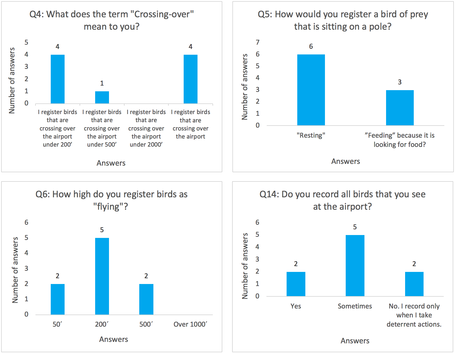
To see the answers from all 4 airports press: Airport A, Airport B, Airport C or Airport D
In conclusion, the bird controllers are all collecting data in accordance with IBSC standards. However, they are collecting substantially different data. The Airport’s response to this new information was to immediately create an action plan with the following items:
- Education of bird controllers focusing on:
- Species recognition;
- Assessing the number of individuals in a flock;
- Standardised use of the Wildlife Registration solution, for:
- Crossing birds;
- Registration of birds crossing based on the altitude;
- If no birds are observed a “no activity” option is entered minimum every 30 minutes;
- Continuous performance monitoring:
- This will be done with “Data quality reports” (as described below);
- Bi-annual surveys to identify inconsistencies;
Data quality reports
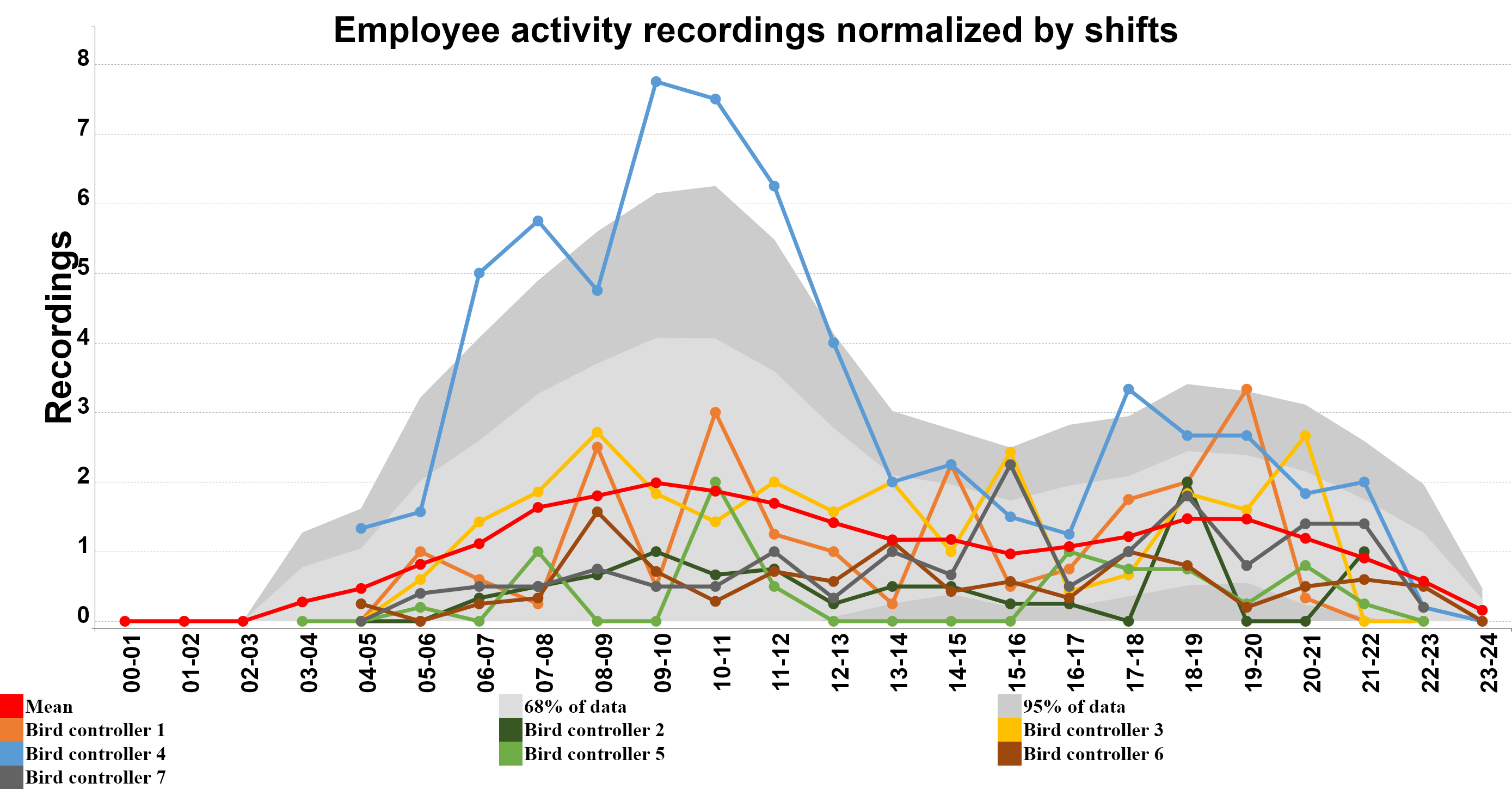
While talking about data, can we spot inconsistencies by looking at how the data is collected? The quick answer is yes – it looks like it. The bird controllers are using our digital recording service, which means we are receiving the data in real-time, when the recordings are made.
We normalised the data by looking at the numbers of bird recordings, no activity recordings and bird controller movements (measured as device position in 25-meter intervals) in hourly intervals, divided by the number of shifts. A shift is defined as the number of different days when recordings have occurred in the given time interval. The average is calculated as a smoothed average by including the hour before and after to avoid spikes in the data.
Based on this it becomes evident, that there are inconsistencies in the number of recordings (graph 1) performed by the individual members of the bird control unit over a 30-day period. The data is divided into one-hour intervals over a 24H period. From this, we can see that bird controller 2 is making way more recordings than bird controller 6. We see similar tendencies in recordings of no activities as well as movements.
This information is consistent with the result of the survey.
Conclusion
Gathering data in accordance with IBSC standards is commendable, but it requires training and education. The training should be based on continuous performance monitoring. The airport should focus on developing bird control staff skills, based on the inconsistencies in the data. This can be done by surveying and analysing the way data is collected – as in the example above.
A standard for what to collect is not enough in itself. We need to describe and standardize how data is being recorded – not just write data in a protocol or capture it in a digital service. When seeking to gather actually valuable data, this is essential.
What is the bigger picture here? If we want to be able to compare data across airports, the standardization becomes even more important. This is a natural process as digital data capture and analysis is moving into the industry, we can enable management and staff to make well-founded decisions – if we focus on data quality. To support the data quality, analysis reports will be available to all our customers (see example here).
So, are you making the right decisions based on flawed data?

AirshareXYZ present at the World Birdstrike Association Conference
The AirshareXYZ project is focusing on establishing a collaborative industry approach to wildlife management in order to secure safe and continuous uninterrupted operations for airlines and passengers.
The immediate project focus is to gather experience and feedback from airports in order to create an understanding of the most effective wildlife management actions and establish a knowledge sharing ecosystem. The AirshareXYZ is an attempt to identify key factors and concrete elements of an efficient wildlife control and reduction plan and share this knowledge across the industry.
In other words, the AirshareXYZ project is crowdsourcing the best possible wildlife control and reduction practices.
In the first part of the project, the use of different types of mitigating actions has been mapped out across destinations around the world that are participating in the AirshareXYZ project. The next phase will be to ask airports to share their experience on the use of mitigating measures, efficiency, species, etc. The vision is to give airports access to experience and knowledge from peers at other airports, as well as actively communicating with airlines where and how the risk can be reduced.
The initial survey has been sent out to 700+ airports worldwide. The follow-up questionnaire will be drafted at the WBA Conference during the Data & Oversight workshop, using the experience of worldwide experts. We would appreciate your input during this process – join us at the workshop at the WBA meeting. You can sign up here.
Collaboration is the key to success! It is important to understand that the AirshareXYZ project is not an assessment; it is an attempt to establish a cross-industry collaboration. The results of the project will be published on the AirshareXYZ project website, where you can also find monthly progress reports and much more.
Airport participation is essential– but completely voluntary. Airports approve with whom they wish to share their data. In all public analyses data is anonymised to a continental level.
See you in Warsaw on 19-23 of November 2018 – remember to sign up!

Can satellites help prevent bird strikes?
Wildlife behaviour in the airport surroundings has a direct impact on the risk of collisions between birds and aircraft.
Monitoring and management of the airport surroundings can help to mitigate the risk of bird strikes, but it is a huge area with a long list of stakeholders. So, how can we solve this? In order to identify changes in the area, you actually need to know what the area looked like before the change. To illustrate what we are talking about, we created a demo of Billund Airport (Denmark). You can open the satellite map in your browser by clicking the link (the demo works in Safari and Google Chrome – apologies to Internet Explorer users).
The map within the circle covers 530 km2. Using the slider in the bottom of the map in your browser, you can see the differences between the same area in May 2017 and May 2018. If you look at the grid G7, you will notice that the gravel pit is expanding. Now we can assess, if the change has a relevant impact on the airport. In this case, the change is relevant, since the gravel pit might have standing water, thus attracting birds. The next step would be to establish a dialogue with the landowner – in this case, the focus could be on limiting the amount of standing water.
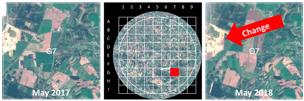
To sum up, we can use satellite images to identify landscape changes. Identified changes should then be combined with local wildlife knowledge, to assess if the change could have an impact on wildlife behaviour, leading to an increased risk for aircraft operating in the area.
If we look at this from a safety management perspective – just identifying the change is not going to do the job. We need to assess if the change poses a risk. If we identify a risk, we need a plan to mitigate it and we need to act on the plan. With this in mind – the answer is yes, satellites can help prevent bird strikes. Satellite images can be directly integrated into your wildlife risk and reduction plan.
It might also be a good idea to keep an eye out for maize fields and other winter crops where wildlife can come to forage – winter crops are visible in the satellite images. Aarhus University (Denmark) has published an article from March 2018 about the new patterns of hundreds of thousands of geese roaming Europe, in search of food and habitat. The growing populations of barnacle geese and pink-footed geese (both increasingly foraging on maize fields) in Denmark and elsewhere in Europe, are not only creating a challenge for the farmers, but also posing a significant risk for aviation.
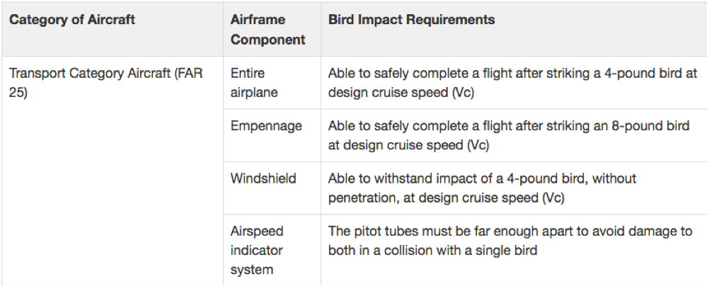
A fact worth mentioning - a transport category aircraft is designed to sustain an impact of a 4-pound bird at cruise speed (Vc). An avian heavyweight like a goose breaks this limit, resulting in an impact force way above design criteria – food for thought.
If you would like to see a satellite map of your airport surroundings – just fill out a few questions here and we will send it to you.
Written by Peter Hemmingsen (CEO, AscendXYZ)

Are warnings on high bird activity meaningless without standards?
Recently I have been giving quite a few thoughts on standards of "bird activity high", or rather the lack of them. If you have 5 minutes, I would appreciate your feedback.
- Do you reduce speed and/or turn on landing lights on approach if you hear “bird activity high” on ATIS?
- Would you reduce speed and/or turn on landing lights if the information was based on a standard?
- Do you include bird activity in your briefing today?
- Would you include this in your briefing if it was based on a standard?
What is the point with these questions, after all?
From time to time pilots are issued warnings about "bird activity high" on ATIS. Ideally, this would prompt a set of actions corresponding to the situation – typically turning on the landing lights, reducing airspeed or a combination of the two.
The question, however, is whether warnings about high bird activity have any real meaning, as long as there is no official standard regulating when airports report “bird activity high.” Even worse, some airports issue warnings per default, thus rendering the information essentially meaningless.
So how could a standard increase the value of these warnings? Do they even matter in the first place? Let us look at the factors at play.
How to reduce risk: Speed is of the essence!
Although bird strikes rarely lead to fatalities, they are the direct cause of significant damage to planes, as well as dents in the profit of airlines.
One of our clients, a major European airline, reports approximately 600-800 bird strikes a year. Each bird strike amounts to an average cost of € 56,000, split almost evenly between costs going towards repairs and indirect costs such as compensation to passengers, re-booking of flights etc.
Therefore, a fair warning leading to an efficient response avoiding a strike or minimizing the potential damage is of the essence.
If there is, in fact, high bird activity in a given area, the operational response to a “bird activity high” could very well be: “Reduce your speed," as a 15% speed reduction reduces the impact energy by approximately 1/3. As a direct result, the risk to pilots and passengers, as well as related costs of following repairs are reduced significantly.
To understand what the speed means for the impact, I looked at the kinetic energy in the table below:
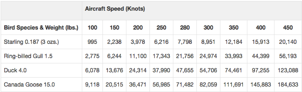
On an Airbus 321 cruising at 250 knots, a 15% reduction to minimum clean speed 210 knots could have a significant effect. When looking at FAR 25 design criteria and impact speed, it becomes evident that a mere 15% reduction in speed, could bring you within the design criteria – even in case of a collision with an avian heavyweight like a Canada goose.
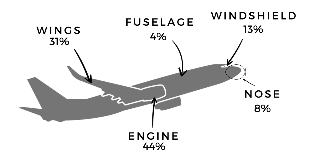
These points are essential to keep in mind, considering the risk in case of a bird strike on engines or, especially, the windscreen.
Not only are these areas among most critical, but also where the majority of bird strikes actually happen. This should be clear from the illustration below, showing the locations and percentages of impacts, based on statistics from pilot and maintenance reports:
Where is the risk?
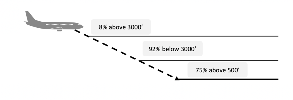
The risk of bird strikes increases with proximity to the ground. Most of the time a speed reduction will be possible. The consideration here is, that a speed reduction would also lead to a slightly prolonged airborne time. However, we are talking about 1-2 minutes of the flight, and only when a trustworthy high bird activity message is given.
The data is already being collected – let’s use it!
Most airports have bird control staff that are already recording the bird activity, and are taking action to remove the birds from the aircraft operation area. That means that the data is already there, now we “just” need to apply it by agreeing on a definition of high bird activity.
A note here could be, that the bird activity data will be generated based on what is happening in the airport operations area, not in the surrounding areas where the aircrafts are approaching/departing. It is, however, the only data source we have in most airports.
It is fairly simple to formulate a basic equation, that could work as a basis for determining when to issue a high bird activity warning. For example:

The calculation could also be based on the risk level of the recorded birds (in the airport’s risk matrix), although that would require all airports to use the same risk matrix in order for the information to be standardized.
General operational response
When looking at the operational response to a “bird activity high” statement, we see following possibilities (2):
Approach:
- Reduce speed;
- Turn on landing lights;
- Include in briefing;
Landing:
- Low thrust settings;
- No go-arounds – fly through and land;
- If a strike occurs – do not use reverse thrust;
Take-off:
- Include in briefing;
- Turn on landing lights;
- If birds are present – request them to be removed.
Thank you for taking the time to read the article. I look forward to receiving your feedback on this topic by sending me your thoughts at [email protected].
Written by Peter Hemmingsen (CEO, AscendXYZ)
Sources:
1: Transport Canada, Bird impact force: https://www.tc.gc.ca/eng/civilaviation/publications/tp13549-appendices-appendix12-1-410.htm
2: FLIGHT OPERATIONS BRIEFING NOTES OPERATING ENVIRONMENT BIRDSTRIKE THREAT AWARENESS: https://www.skybrary.aero/bookshelf/books/181.pdf
3: FAA/USDA wildlife strike report: https://wildlife.faa.gov/downloads/Wildlife-Strike-Report-1990-2015.pdf
4: Boing: Strategies for prevention of bird : https://www.boeing.com/commercial/aeromagazine/articles/2011_q3/4/

Peter Hemmingsen's (CEO, AscendXYZ) vision for the Danish space industry (English version)
Are we ready for the data stream from above?
Contours are forming of an industry which not only works purposefully on making data from space available but which will also have a huge transformative effect on people, societies, trade and industry. Denmark can participate too – but only if we dare to take risks and are ready to begin our effort already in the educational system.
In recent years the number of companies working with data from space has exploded. This changes our world, but at this point, you would have to be a specialist to notice.
Some possibilities are so obvious and well-known that they are almost trivial. Almost all of us have an advanced GPS receiver in our smartphones, for instance, which makes it a lot easier to locate that rented summer house in the other end of the country or perhaps just the nearest gas station. Other possibilities are only in their infancy or are yet to be discovered.
This development will only accelerate, and it will impact both the public sector, trade and industry and you. Even though you may not have realised it yet.
Finance and insurance: Satellite data to help decide the price and estimate the risk
Insurance companies will be able to easier survey the areas they insure, improve their claim management and focus their sales effort through automated and targeted analysis of satellite data. Banks can estimate a company’s turnover and value based on e.g. traffic data and the number of visitors in the company parking lot. Forestry can be priced and sold through satellite-based analyses. Not only does this provide the financial sector with more precise data, it also paves the way for truer and more accurate offers – as well as for entirely new business areas.
Food and agriculture: Autonomous machines and intelligent fertilisation
Satellite data and photos of the fields taken on-site – e.g. by drone or from a plane – are combined with algorithms to optimise the use of fertiliser. Information is transformed into detailed field maps that allow the tractors to steer themselves with the aid of satellite navigation. This increases agricultural efficiency while minimising waste and leaching of nutritional substances to the aquatic system. Such a scenario may sound like science fiction, but it is indeed becoming a reality.
Education: Satellites in class
Satellite solutions are already a part of the teaching in public schools and upper secondary schools, but we could be more ambitious. In Denmark, for instance, Sentinel Playground and Copernicus Open Access Hub can be used to turn yesterday’s photos into part of today’s teaching and inspire pupils to use data and knowledge in entirely new contexts. In a not-too-distant past, Knud Hemmingsen (my father) used a lot of research on the economy, geography, climate and more to write "Verden i temaer og tabeller" (The World in Themes and Tables) for use in public schools.
Today, pupils can follow rainforest reduction on a weekly basis or see the development of Danish rapeseed fields in May by comparing free Sentinel photos. The possibilities exist, and the potential for application is unlimited.
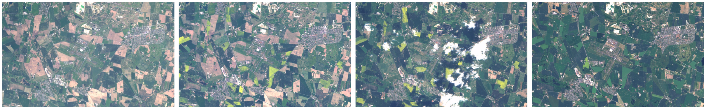
Fields around Roskilde Airport from May 5 to June 12
However, we need many more teachers and institutions to demonstrate the possibilities to generations entering the universities and the Danish companies. This requires active participation from the trade and industry sector, as well as the research community. New ideas, solutions, and innovation require better knowledge about available data, as well as a strong vertical understanding of individual business areas.
A critical view and special qualifications
The more companies that focus on using big data from space, the faster the need for specialist employees arises, which can turn into a bottleneck quickly – just as we experience in the IT sector today. If companies cannot recruit data scientists and software engineers, they cannot improve their business. Specialists with the right qualifications will become even more attractive, and it is with good reason that Harvard Business School proclaimed data scientist to be ”The sexiest job of the 21st century”.
There are lots of examples of how data is used already today. I recommend looking to ESA Business Applications for inspiration.
New business areas in development
Many industries focus on space data. But even though the application case may be clear, implementation is not always easy. The benefits of big data from space typically take the form of optimisations, better end-user understanding, logistical improvements and – perhaps most importantly – new products. When we combine the enormous amounts of historical and near real-time data with machine learning, new patterns and contexts emerge that were not available before. In addition, there is a variety of already existing or near-market solutions that crop up all over the world, helped along by initiatives such as the European Space Agency’s ”ARTES Applications Programme”.
Accessibility is a prerequisite for success
All the efficient solutions share one thing in common: the combination of a relatively complex concept like satellite data and a strong understanding of a specific work area, wrapped up as an accessible solution for the end user.
You could say that no one wants more data. Only results count.
As users, we do not really care how our smartphone works in detail, for instance, if we have easy access to the Internet, mail, navigation, streaming, etc. In the same way, users do not care if data are accessible somewhere if there are no solutions that make them easy to use in practice. In this area, there is a great potential for development for Danish companies in an overwhelming global market.
I have no doubt that data from space will change our everyday lives – because it is already happening. Likewise, the question is not if we will see new solutions that use big data from space – but which role Danish companies and researchers will play.
To understand how we bring about changes in companies’ and consumers’ lives, we must include them in the process. We need to include those who will be using the solutions in the development process to match our products and services to their needs. This requires us, as companies, to be able to communicate the possibilities – also to those who may not have the same professional background or who may not be able to see and understand all the exciting possibilities.
But are there as many possibilities as we think?
Yes. The possibilities are there. But they require a strong focus from the Danish trade and industry sector and research community if we are to get our share since many other countries and companies are already in the race.
Companies that develop solutions based on satellite data work for a global market. In other words, they produce knowledge-based export that we should support. In this context, we should focus on both near-market solutions and long-term research and development. Quite simply, we cannot afford not to do anything, and we need to get on the train before it picks up so much speed that we can no longer jump on board.
This will not only open possibilities of a traditional financial nature; it will also give Danish companies let help define the solutions that will revolutionise the way we perceive the world. That is not a bad target to aim for.
Written by Peter Hemmingsen, CEO at AscendXYZ.
You can access the Danish version at the website of the Danish Ministry of Higher Education and Science here and here.

A Holistic Approach to Wildlife Risk Assessments
Wildlife Hazard Management (WHM) at Copenhagen Airport is moving away from conducting generic step-by-step Wildlife Risk Assessments (WRA) based on “One size fits all”. The approach is becoming more holistic following the notion that conducting WRA’s are like assembling a puzzle where data is the pieces and every picture is unique; therefore, the more different types of data we include in the WRA, the more cohesive and clear the picture becomes.
One of the cornerstones in our WHM is the Wildlife Risk Assessment Matrix (RAM), developed by John Allan (‘A Heuristic Risk Assessment Technique for Birdstrike Management at Airports’, 2006). It allows you to assess a bird species risk to flight safety based on the Frequency and Severity of a birdstrike. The RAM functions as the starting point, or the first puzzle piece, creating an overview of potential wildlife hazards in need of comprehensive WRA’s.
The next puzzle piece is data collected by Bird Controllers. At many airports Bird Controller data includes presence (number) and behaviour of the bird species observed at the airport, thereby offering knowledge on the potential risk posed by each species. Moreover, it may guide you towards the root cause of the risk, that is “what is causing the behaviour?”. Root causes may be identified by comparing observational data with general knowledge on the biology of the specific bird species.
Bird Controller data may also reveal if a certain species is passing over the airport, e.g. daily or seasonally, without actually using the airport directly. If that is the case, data collected in the surroundings of the airport is needed to enable identification of the root cause. A good place to start is mapping all bird attractive areas in the surroundings of the airport, for example wetlands, nature reserves, farmlands, open dumping sites and so forth, and subsequently collect data on presence and behaviour of the species. If data reveals that the species at hand are present at a certain nature reserve, data on movement patterns can further elucidate if individuals or flocks are performing a movement pattern, e.g. daily foraging trips from the nature reserves to another site in the surroundings, making it a risk to flight safety. 3D avian radar offers comprehensive data collection on movement patterns.
The last type of data I will touch upon is Stakeholder Narratives. This type of “soft data” can be very useful to include in a WRA. Local communities surrounding the airport float with people who can tell a story regarding local wildlife and their habitats. Farmers, hunters and forest rangers all have their angle on the local wildlife and how it has evolved the previous decades. It is crucial to have in mind the premise of the knowledge you gain from Stakeholder Narratives, e.g. the potential of hidden agendas colliding with flight safety. That being said Stakeholder Narratives can contribute with some important aspects. First of all, it can elucidate the complexity of doing WHM outside the airport fence. So many local stakeholders are in play all with different perceptions of the issue at hand. Understanding this complexity is essential when WRA’s are to be converted into concrete management initiatives. Furthermore, showing an interest in the local community, and letting them know that the airport is interested in their story, might just create some good-will for later on when an initiative that might affect them is to be implemented. Secondly, those in charge of granting money for different projects at the airport are most likely not wildlife specialists. So, to be able to move on with your wildlife project, you need to be able to tell a story that first of all is evidence-based, and secondly, can catch their attention. The Stakeholder Narratives can be the spice that makes the story come alive and makes it stand out. That should never be underestimated.
To sum up, WRA’s should be holistic because that is how you ensure that all angles and all potential risks have been taken into account. To do so you need to include a wide range of data, from the newest technology to going out and having a chat with the local farmer. WRA’s need to be evidence-based, otherwise we risk wasting resources managing something that wasn’t in need of any managing, worst case we may create a wildlife hazard that was not there, to begin with. However, it is important to remember that evidence or data comes in many shapes and forms, each having both strengths and weaknesses. If you include many different types of data you increase the chance of covering all the aforementioned weaknesses, hence ending up with a strong WRA.
Written by: Camilla Rosenquist, Wildlife Manager at Copenhagen Airport (Denmark).
You can contact Camilla Rosenquist on Linkedin.

How to improve the wildlife deterrent effect of your airfield grass?
Author: Mogens Hansen — Aviation Wildlife Biologist MSc.
Almost all airports maintaining large areas of grass are spending resources to keep the airfield grass less attractive to wildlife. However, birds and mammals are still entering the airport to explore the airfield for food and rest. Bird controllers in place are the next defense against the wildlife and even though the bird controllers are fighting bravely, the birds are not giving up. But there is a third powerful defense — the chemical weapon produced by nature itself — the endophyte containing grass.
Natural grasses like Tall fescue and Ryegrass can contain natural fungi inside their tissue (the so-called endophytes). In such instances, the grass and its fungi are living happily together. The grass delivers shelter, water, and nutrients to the fungi, and the fungi pay back by producing some chemical compounds — alkaloids, that act against the grass eaters e.g., insects, mice, and geese. The alkaloids produced by the fungi to some degree inhibits the digestion of the grass, consumed by the grass eater. Consequently, if all the grass is containing such fungi it would result in fewer grass eaters, as the production of grass eaters will be slowed down by the reduced speed of food uptake.
In the wild nature, only a small and variable fragment of Tall fescue and Ryegrass has fungi inside. The fungi do not spread itself from one grass host to another. The only way for the fungi to survive, is to inhabit every single grass seed and follow the seed during the spreading and germination.
If you have Tall fescue and Ryegrass as a part of your airfield grass, a small fraction of them will certainly have endophytes. However, this fraction is not big enough to produce a deterrent effect on grass eaters. If instead, you imagine that nearly all grass has endophytes — you may see an effect.
But how can you achieve a nearly hundred percent endophyte containing sward of Tall fescue and Ryegrass? The answer is simple: by reseeding with endophyte containing seeds of Tall fescue and Ryegrass.
It is possible to buy grass seeds of Tall fescue and Ryegrass in large quantities, where almost all seeds contain endophytes. So, it is, in fact, practical to reseed for the establishment of an endophyte grass dominated airfield.
It is, of course, a difficult project to reseed the airfield. However, more attention must be paid when you are reseeding with endophyte containing seeds. The endophyte fungi in the seeds are living organisms and as such can die. Therefore, care must be taken to keep the fungi living until the seeding. So, keep the seeds in a cold and dry environment during the transportation and storage period. Further, endophyte grass has to be managed kindlier during the establishment and during the growth the years after, but it is another story.
Close studies of the effect of endophyte containing grass to birds, have been carried out at airports in New Zealand and the USA with promising results. Finally, ICAO suggests the use of endophyte grass as a method to reduce wildlife attraction to airport ground cover according to the ICAO Doc 9137, Airport Services Manual, Part 3.
All in all, it is worth to consider the establishment of this third defense measure against the wildlife. If you decide to go further, I am in a position to guide you. Just contact me via my LinkedIn profile: Mogens Hansen.
Mogens Hansen
CEO (MSc. in Wildlife Biology)
![]()
Prinia Consult
Sjællandsgade 59C 404
DK-2200 Copenhagen N
Phone: +45 30 89 81 18
Email: [email protected]
Bird Strikes down by 50% in Aalborg Airport
Written by Thomas Hugo Møller (Quality and Compliance manager at Aalborg airport).
By using data to understand wildlife behaviour and implementing new active measures, Aalborg Airport (Denmark) has reduced bird strikes by one half in one year.
Aalborg Airport is a growing civil and military airport in the northern part of Denmark. Situated close to the water, with large meadows and huge areas with flooded pastures in the immediate surroundings, managing wildlife is a challenge. Add a rapidly growing Barnacle goose population, and you have a problem. So, what were we to do?
We started by implementing a strict digital recording of all wildlife movements in the area. This lead to a better understanding of the bird behaviour. Due to the digital recording, we were able to map where and when our high-risk species were present and to track their local migration patterns.
With this information in hand, we started to focus on our active measures — extra “boots on the ground” in high-risk periods, new tools (e.g., remote controlled gas canons, structured hunts) to target and change local migration patterns. This, combined with education of the bird control units and strong management support, has yielded results. We went from 37 bird strikes (2016) to only 18 strikes (2017), and that with movements increased by 8 %.
What’s next for us?
In 2017 Aalborg airport was a part of the Airshare XYZ project. The Airshare XYZ project currently is supported by 13 European Airlines and more than 90 airports globally. The project is focused on sharing the knowledge, understanding how other airports and airlines are mitigating risks, what works and what doesn’t, and how we get the best effect of the measures we take. We hope to see our colleagues around the world participating and sharing their knowledge in this field.
Aalborg Airport is the first airport in Denmark to install an Avian Radar. Avian Radar allows us to give our bird control units real-time information on bird activity in the airport operations area, enabling them to take immediate actions. By combining our digital recording data with radar data, we expect to gain important insights on the effect of our area management plan. Last but not least, we will be able to map bird activity in our surroundings. It is exciting times — possibilities, understanding, and technology are changing the way we perform wildlife control and reduction. I hope this post inspired you to share insights from your Airport or Airline with the rest of us.
For more information contact Thomas Hugo Møller (Aalborg airport) on LinkedIn.
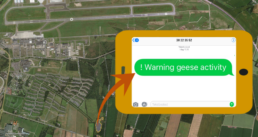
Listening for geese!
75% of airports participating in the Airshare XYZ project record hazardous birds at sites that attract birds. We found something new in the field of airport safety, that might help identify hazardous sites and would like to share it with you.
The Danish company Wildetect has developed a device called "BirdAlert" that monitors the sounds from different bird species.
BirdAlert is an intelligent system that recognizes specific species of birds, by listening for them through the special BirdAlert microphone. In 250-meter radius, the system recognizes rooks, gulls, geese, and starlings by their unique sound.
Most airports are monitoring sites in the surroundings by visual inspection. This process is time-consuming. Furthermore, it does not give the full assessment of the wildlife activity, since it is not done very often. BirdAlert listens to the sounds for you 24/7. The information can be made available to you, in an easy to use web solution. This gives you a valuable insight and helps to identify the hazardous sites where action needs to be taken. The system runs on solar power and is self-sustained. The bird sounds are recorded and classified, data is sent to the web-service enabling both real-time actions and historical analysis.
If this is relevant to you, please give your feedback in the survey we made here.

Sharing is caring!
We are glad and proud to see that Airshare XYZ project is growing! A few months ago, we started creating monthly updates to inform all the participants about the project status, changes and last, but not least – to share interesting articles and posts from different airports and wildlife management professionals. We believe that sharing the knowledge and experiences is important to all participants, in order to get inspired, find answers or start discussions. Based on positive feedback from project participants, we decided to make these monthly updates available on our website (you can access them here).
To those of you who have not heard about the Airshare XYZ project, we introduce this project as a cross-industry collaboration between more than 13 airlines (such as AeroLogic, Air Dolomiti, British Airways, Brussels Airlines, Condor, Danish Air Transport, Edelweiss Air, Lufthansa, Lufthansa CityLine, Norwegian Air Shuttle, Pegasus, Thomas Cook, Widerøe and other) and +500 destinations. The project was initiated by Ascend in collaboration with airlines and airports, with the purpose of developing a platform to streamline and easily share safety management related questions.
So, what does it mean to participate in the Airshare XYZ project?
Upon receiving the first request from one of the airlines (flying to that destination), airports are asked to fill out the questionnaire and then approve to share the information. This project enables airports to answer "one time and in one place", and thereby avoid answering different airlines in multiple formats. Once the data is entered, the airports can share it with a new airline with a single click. When airports update the entered information, it will be automatically updated on the airlines’ subscription too.
The objective of the project is to provide airports with an understanding of what actions are being taken to reduce the presence of wildlife in other airports, and what effect they have, thereby enabling the best possible wildlife control and reduction programs in each individual airport.
You can read more about the project here.

Ascend mentioned in the SPARA 2020
Recently SPARA2020 (Smart Peripheral and Remote Airports) members and HIAL received presentations from a Danish collaboration on emerging technologies that may be of interest. Ascend has presented wildlife monitoring tools and obstacle detection in online software solutions developed closely together with the European Space Agency (ESA).
The SPARA2020 Danish briefing can be found here.